BlackSky and Palantir’s pilot program boosts geospatial intelligence
New solution offers real-time insights on ground-based events from space

BlackSky and Palantir have announced the results of their geospatial pilot project.
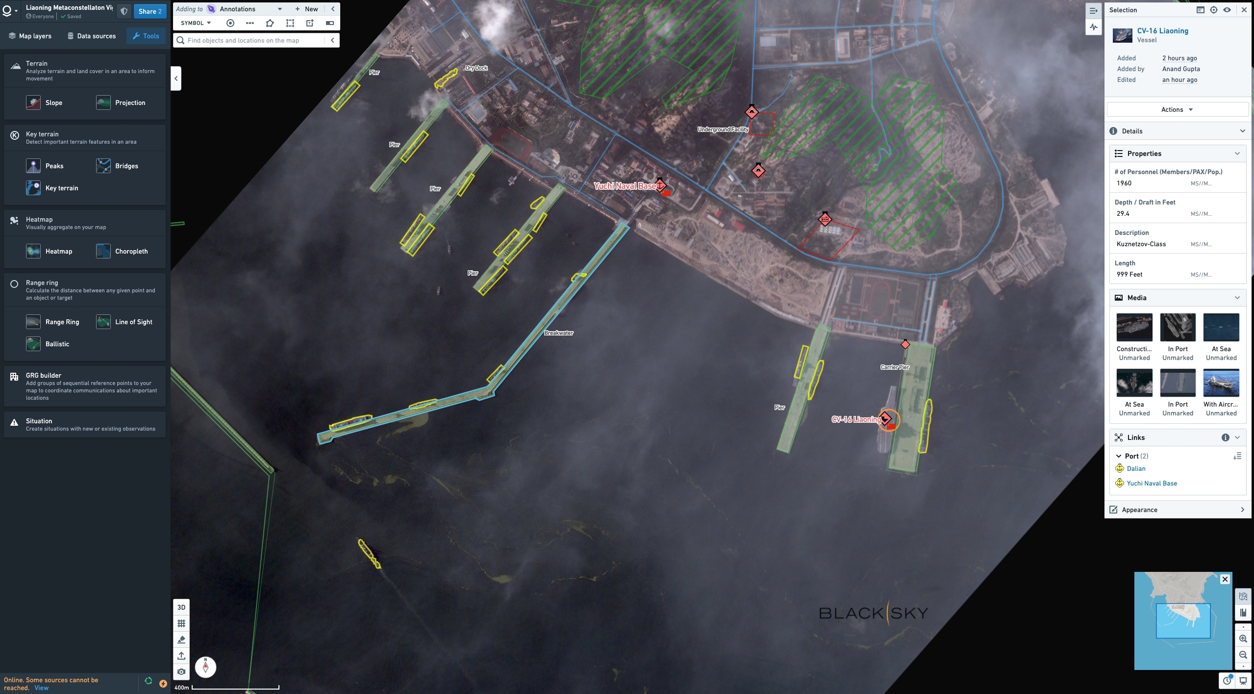
As part of their strategic partnership, BlackSky integrated commercial satellite imagery and analytics with Palantir's enterprise platform Palantir Foundry.
This combination creates an intelligent monitoring system capable of predicting Earth events from space. The solution pairs high-resolution imagery with deep analytics to encourage proactive decision-making.
In a series of exercises, the pilot program's capabilities were successfully demonstrated to experts in geointelligence. Most notably, the BlackSky-Palantir solution will help government and defense intelligence squads execute time-sensitive operations.
“Our joint pilot program with Palantir highlights the vital impact of real-time insights,” said Brian O’Toole, BlackSky CEO.
O’Toole continued, “The use of our data and analytics in these types of exercises drives demand for our geospatial intelligence as customers experience the rapid delivery of first-to-know insights that can inform proactive strategic decision making.”
Commenting on its analytics platform, BlackSky said Spectra AI spots potential threats in high-risk locations such as airports and construction sites. Through computer vision, the platform detects movement, damage, and anomalies in critical areas.
Sign up today and you will receive a free copy of our Future Focus 2025 report - the leading guidance on AI, cybersecurity and other IT challenges as per 700+ senior executives
With Spectra AI incorporated into Palantir Foundry, geospatial analysts can access real-time insights on ground events without human intervention.
“Our collaboration with BlackSky radically compresses the decision-chain for warfighters,” said Shyam Sankar, Palantir Technologies COO.
“It gives users unprecedented control over orbital sensors and operationalizes AI insights from space to support better, faster decisions on earth. Palantir’s software continues to provide the operating system for operational decision-making at the edge across domains, from space to mud.”
-
 What is Microsoft Maia?
Explainer Microsoft's in-house chip is planned to a core aspect of Microsoft Copilot and future Azure AI offerings
-
 If Satya Nadella wants us to take AI seriously, let’s forget about mass adoption and start with a return on investment for those already using it
Opinion If Satya Nadella wants us to take AI seriously, let's start with ROI for businesses
-
 SAS leans on synthetic data and digital twins to support business data demand
News SAS has announced new synthetic data capabilities and support for digital twins in a bid to equip enterprises with concrete platforms for data-driven decision making.
-
 Alteryx unveils double leadership appointment in fresh growth drive
News Alteryx has announced the appointments of Jon Pexton as chief financial officer and Steven Birdsall as chief revenue officer.
-
 Three-quarters of data analysts are still reliant on spreadsheets and manual preparation – but AI tools are now transforming the profession, boosting productivity, and supercharging efficiency
News Data analysts are still largely reliant on spreadsheets and manual preparation techniques, but AI and automation are shaking things up.
-
 More than a number: Your risk score explained
Whitepaper Understanding risk score calculations
-
 Automate personalization with AWS
Whitepaper How marketers can automate, deliver, and analyze billions of personalized messages and offers per day
-
 How LaLiga championed big data to transform data analytics in sport
Case Study Spain’s premier football division is hoping to transform not just football but sport as a whole with its data analytics efforts
-
 Three ways manual coding is killing your business productivity
Whitepaper ...and how you can fix it
-
 Oracle adds new capabilities to Smart Construction Platform
News New analytics enable continuous improvement across project planning, construction, and asset operation